On Top of Down Under

The Seven Summits comprise the highest peak on each of the continents—Mount Everest, obviously, Denali in Alaska, Mount Kilimanjaro, and so on. For many, ascending each of these seven mountains is a lifelong dream. However, not all seven peaks are created equal. Obviously, Everest is the hardest not only for its technical difficulty but also for the tens of thousands of dollars cost of its permit, while Kilimanjaro is a multi-day but non-technical hike that can be accomplished by hikers without mountaineering experience.

Looking at Kosci from the start of the Main Range Track

Then there’s Mount Kosciuszko. At 2,228 metres, it is only a quarter of the height of Everest, and can be summited in a single day—or less, if you take the route that includes a chairlift ride most of the way to the top. Some rankings of the Seven Summits don’t even include Kosci, replacing it with Puncak Jaya in Indonesia by considering Australasia the continent rather than Australia. But since I don’t have any desire to ascend all seven summits (I’d like to do Kilimanjaro in a few years, but I don’t see myself ever tackling the others), I’m happy to consider Kosci among the peaks.

Steve and me at the start of the hike

Last week, Steve and I rented a car and drove seven hours from Melbourne to Mount Kosciuszko National Park in New South Wales to hike to the highest point in Australia. We stayed overnight in Jindabyne, about half an hour away, and got up bright and early on Friday morning to head up the mountain. In order to make it more of a hike, we forewent the Threadbo trail with its chairlift and headed around the other side to Charlotte Pass for a 22km loop trail that connected the Summit Road and the Main Range Track.

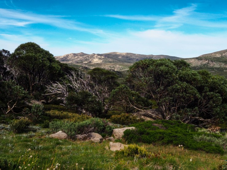
The first thing that surprised me was how beautiful it was. I was expecting a dry, sparse range based on the endless stretches of red dirt and leafless trees we had passed on the Hume Highway on the way up, but the views were actually mountainous and lovely. The track was also wonderfully peaceful. On our way up, we only encountered one other group—a pack of older folks kitted out with tramping poles and wide-brimmed hats, who kept up a solid pace even on the steeper sections. There was no one blasting shitty EDM off their cell phones for all to hear, thank christ.

On the way to the summit

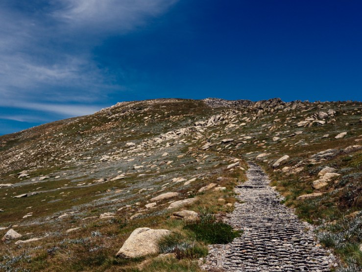
The top was a bit busier because the three trails—Summit, Main Range, and Chairlift—converged (I’d guess most folks came up on the chairlift based on the lack of daypacks or hiking boots) but it was still very quiet compared to some of the hikes I’ve done in New Zealand and elsewhere. A surveying trig and elevation sign mark the summit, where we took a break for lunch before following the mild downward grade of the Summit Road back to our car.

At the top!

The hike took us just over six hours in total, lunch included, and was only strenuous in its length, but it was still a fun way to spend a few days (on the trip, we also drove up to Canberra to visit the NASA Deep Space Communications Centre and the National Gallery and Museum), and it’s fun to be able to say we’ve climbed one of the Seven Summits, no matter how small.

Surveying trig marker at the summit 
Advertisement

National Parks During the Shutdown: Three Ways to Help

Whenever someone I meet in my travels asks me the best thing about the United States, the National Parks system is always the first thing that immediately comes to mind. There are plenty of places in the world that have incredible national parks, but the National Parks of the USA are special in their breadth and scope. Rock formations and rainforests, caves and canyons, islands and geysers and volcanoes and mountains… there’s something for everyone, representing the most incredible of Mother Nature’s offerings and welcoming over 300 million visitors per year.

Like everyone who love the National Parks system, I am heartbroken to read about the damage being caused to the parks by unsupervised visitors during the government shutdown. Trash overflows the rubbish bins, and let’s not even mention the toilets. Worse, there have been reports of vandals cutting the endangered namesake trees of Joshua Tree National Park in order to create access for their 4WD vehicles. Even during normal operating, there are many instances of graffiti and carved rocks from people who are too inconsiderate to follow Leave No Trace principles, so I can only imagine how much worse it is at the moment.

IMG_7057-2.jpg

If you are also devastated by the destruction these thoughtless visitors are doing to some of the world’s most stunning sites, here are some ways you can help:

Continue reading “National Parks During the Shutdown: Three Ways to Help”

Abel Tasman Almost All To Ourselves

Abel Tasman National Park is one of the busiest spots in New Zealand, with upwards of a quarter of a million visitors per year spending at least a day in the park in recent years. However, the vast majority of these visitors come in summer, to enjoy the beautiful golden sand beaches and warm water for kayaking and swimming. Last week, in late autumn, it was nearly empty, and it was a wonderfully peaceful way to experience one of New Zealand’s most stunning regions.

OLYMPUS DIGITAL CAMERA
View of Split Apple rock from the water taxi

Our trip started with a water taxi from Marahau to Totaranui Bay. We decided to go from north to south because it offered more flexibility; we could take the morning boat and when we got back to Marahau three and a half days later, we’d be back at our rental car and ready to return to Nelson. The water taxi trip was great, taking us to the famous Split Apple rock as well as to see baby seals playing in rock pools near an island just offshore.

OLYMPUS DIGITAL CAMERA
Baby seals getting curious about the boat

I already wrote plenty about our experience between Totaranui and Awaroa hut, but even though the rest of the trip wasn’t as dramatic, there was still so much to see and do. Abel Tasman is full of flora and fauna, beautiful vistas and lush forest, and to be there in such a quiet time (there were days when we didn’t see anyone from the time we left the first hut until the time we reached the next) was amazing.

P5230335.jpg
Fantails’ white eyebrows make them look like angry old men

Our second day in the park took us 13.5km from Awaroa to Bark Bay. Unlike the previous afternoon, day two was warm and sunny. The trails in Abel Tasman are well-marked and don’t have much elevation climb, so the hike itself is not difficult and leaves plenty of time to enjoy the scenery. There are also a couple of fun bridges to cross over estuaries and streams.

OLYMPUS DIGITAL CAMERA
The high-tide bridge across Torrent Bay estuary

We arrived in Bark Bay to find a family had already arrived at the Bark Bay hut and started a fire in the stove, making the lovely space extra nice and cozy. After sunset, we walked out to the beach at Bark Bay to take some photos of the night sky using my camera and tripod. Across the Tasman Bay, in the distance, there was a thunderstorm and with a little luck and a lot of mistimed shots, I managed to capture it in one photo.

OLYMPUS DIGITAL CAMERA
Lighting across the Tasman Bay

The start of our third day in the park was a bit grey and drizzly, but as the morning went on the weather cleared up and the sun hitting the last of the raindrops made for some beautiful rainbows.

OLYMPUS DIGITAL CAMERA
A quick side trip to a lookout near Bark Bay

Day three featured a couple of side trips as we hiked from Bark Bay to Anchorage. We climbed up a steep and less-traversed trail to visit Cascade Falls, as well as taking a much more leisurely ten-minute detour to Cleopatra’s Pool (which must be an amazing place to take a cool dip in the summer).

OLYMPUS DIGITAL CAMERA
Cleopatra’s pool

Anchorage Hut was the busiest and most well-outfitted of the locations we spent the night. Although none of the huts have cooking facilities, they do have flush toilets (although usually a short walk from the huts themselves) and Bark Bay and Anchorage both had a few solar-powered lights). This hut even had solar-powered mobile phone charging cables, which is something I never expected to see.

OLYMPUS DIGITAL CAMERA
Torrent Bay, on the way to Anchorage

The final day, from Anchorage back to Marahau, was quick and easy, and we enjoyed burgers at The Fat Tui before heading off to Nelson for the night. A couple of weka, a kiwi-like bird that we had seen throughout the trip, tried very hard to steal our sandwiches.

OLYMPUS DIGITAL CAMERA
Weka are so cheeky

Having previously done an overnight hike only once before, four days and three nights in Abel Tasman was definitely a new adventure. And so worth it. If you’re okay with chilly weather and love tranquil solitude, I definitely recommend exploring a national park in the offseason. Not only is it easier to do (we booked our huts a few weeks ahead of time, whereas in the summer they fill up months in advance; on other trips such as our road trip we were able to take advantage of first-come-first-serve campsites in parks like Yosemite that become highly in-demand book-ahead sites during peak season), but it’s a great way to enjoy the beauty and power of the site without crowds of other people. And if you choose to go to Abel Tasman, you’ll surely be in awe of the wonder of the world that you encounter.

P5230319.jpg
One of the most beautiful places in the world for sure

Underrated Visual Gems Across the United States

It’s been almost a year since Steve and I set out from Vancouver across the United States, and more than seven since our rusty, faithful-but-not-very reliable junker of a van landed, flat tire and all, in my parents’ driveway in Philadelphia, and our road trip is still something I think about every single day. As I’ve said before—and as everyone I’ve told about it has said—it was a once-in-a-lifetime experience and one of the most amazing opportunities of my life.

I’ve shared tons of photos on here, facebook, and instagram, and I’ve talked about plenty of the incredible things we saw, but I want to get specific about a few of my favourite locations for visual inspiration. However, let’s take a look at the ones that are a bit further off the beaten path—you don’t need me to tell you to go take photos at the Grand Canyon or the Golden Gate Bridge. Here are five locations where I had a ton of fun taking photos and that I would recommend for anyone looking to explore.

Cumberland Falls State Park

IMG_7723

I love waterfalls. Big small, wide, narrow–whether it’s the rushing cascades of Niagara or little more than a ripple in the stream, they’re one of my favourite features in nature. Cumberland Falls is not the largest or most awe-inspiring waterfall you’ll ever see, even if it does call itself the Niagara of the South, but there’s something charming about it. Tucked away in a state park in a rural area of the state—the most notable town nearby is Corbin, known for being the birthplace of KFC—it’s a peaceful, relaxing place to hike and enjoy nature.

IMG_7739

Cumberland Falls is also the home of an amazing natural phenomenon: the moonbow. Similar to when sunlight passes through water and create a rainbow, a moonbow occurs when moonlight passes through water and creates an arc of light. While a moonbow can happen anywhere, there are only two waterfalls in the world where the angle and location are just right for the moonbow’s occurrences to be tracked. One is Victoria Falls in location, and the other is Cumberland Falls. We were lucky enough to be there for a full moon, when the moonbow was most likely to be visible. Although the early summer’s long daylight hours meant that the moonbow was incredibly low and faint, it was still an amazing thing to experience.

Continue reading “Underrated Visual Gems Across the United States”

The Museum of the American Revolution and other essential Philadelphia-area Revolutionary War historic sites

As a kid, it took me some time to realise that everyone in America didn’t grow up within minutes of important historical locations. I grew up in the suburbs of Philadelphia, so I would always say I was from “outside Philly” but whenever I need to give more specificity to people familiar with the area but who didn’t know my small town, I described it as “near Washington Crossing… as in Washington crossing the Delaware.” In addition to being just a few minutes’ drive from this historic location, the towns around mine are full of houses and buildings that date back to the colonial era, I used to work at a school that was owned by a doctor during the Revolutionary War (and is allegedly haunted by a Hessian soldier he operated on there), and, of course, the city of Philadelphia is only 40 minutes away.

603790_10153168766615960_3753087677858423150_n
The Artillery park at Valley Forge National Historic Parka

Yesterday I visited Philadelphia’s new Museum of the American Revolution. A few blocks away from Independence Hall and the Liberty Bell, the museum is the perfect addition to the area. Tracing the events leading up to, during, and through the aftermath of the Revolutionary War, this well-curated exhibit features artifacts from the time period and thorough explanations of significant happenings and people. Highlights include the excellent orientation video, the original tent Washington used as his personal office during the war, and one of the oldest preserved Revolutionary-era flags of the soon-to-be United States. Most of us are already familiar with the basic history due to years of primary education (is it just me, or did we learn about the Revolutionary War pretty much every year?) but the museum does a great job of providing a comprehensive overview while also delving deeper into lesser-known moments, people, and things.

Continue reading “The Museum of the American Revolution and other essential Philadelphia-area Revolutionary War historic sites”

The Best Place I Never Want to Live: Traveling the Southwest United States

The number one place I wanted Steve and I to visit on our road trip—the number one place on my bucket list, in fact—was the Grand Canyon. After we left Las Vegas we headed into the southwest where even in early spring we were faced with the dry heat of Arizona and Utah. We spent almost two weeks traveling from Sedona to Moab before making our way into Colorado, visiting five national parks in the process. Including, yes, the Grand Canyon, which was even more amazing than I could have imagined. In fact, the entire reason was incredible; the national parks we visited were some of the highlights of the trip, there were ample free campsites for us to stay in (ranging from extremely nice to extremely weird, but all conveniently located at the least), and the rock formations both in the parks and along the road were awe-inspiring to witness.

One thing that interested me, though, was that as much as I loved visiting the Southwest, I could tell right away I would definitely not want to live there. Usually when I visit a place I love, I start daydreaming about what my life would be like if I moved there. And I did that a lot on this trip, not entirely hypothetically—Steve and I will eventually have to settle somewhere (probably), and there’s a 50/50 change it’ll be in the USA, so we talked about whether we could see ourselves living in Chicago, Colorado, and other favourite locations. But, and I mean no offense to people who live there and love it, I just couldn’t see myself living somewhere with so much red sand and desert. By the time we left, I was more than ready for rain and grass and more rain.

Still, visiting the southwest was one of the most exciting and exhilarating parts of our trip, and it’s a region I’d love to visit (key word) again. In the future, I want to get a permit to hike the fiery furnace at Arches NP, camp in the Grand Canyon, and explore the more remote sections of Canyonlands. In the meantime, please enjoy these photos of Arizona and Utah:

Continue reading “The Best Place I Never Want to Live: Traveling the Southwest United States”